The engagement of this project has ended
Get project news
Do you want to receive an email when news items are posted?
News on West of Ifield
Back to newsManaging Flood Risk
The development of our draft masterplan has taken into account a range of environmental constraints, including areas identified by the Environment Agency as being at risk of flooding, both now and in the future. We won’t build new homes in these areas and will ensure that our plans are in line with the requirements of the national and local regulatory bodies, the Environment Agency and the Local Lead Flood Authority - West Sussex County Council.
Where the proposed Crawley Western Link crosses the River Mole floodplain, we will design the road in a way that takes account of potential flood risk and will provide alternative ‘floodplain’ provision, ensuring that overall there is no net loss of floodplain and flood water storage capacity.
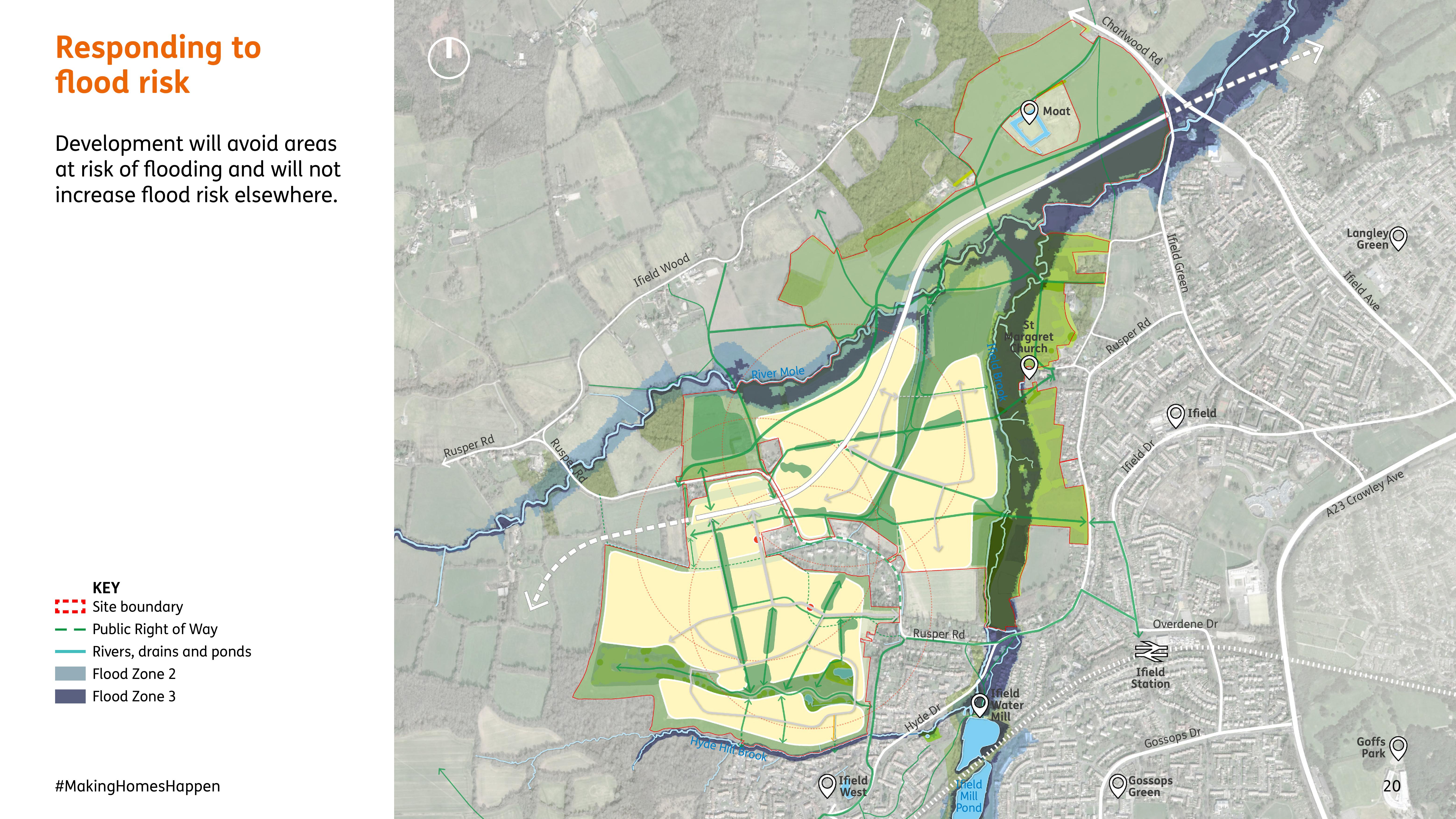
The map above shows the Environment Agency’s flood zones (in different shades of blue) alongside our proposed area of development, in yellow. The different shades of blue relate to different grades of flood risk along the River Mole and Ifield Brook (see table below provided by the Environment Agency) which permits or excludes different types of development or building within them.

The yellow area on the plan shows the maximum possible development area in our masterplan which avoids those areas at risk of flooding. The final extents of development will be set through more detailed design work informed by the Design Guide and fixed by future detailed Reserved Matters planning applications. This approach allows us to put in place further measures to reduce further any flood risk, if this is considered necessary.
As well as avoiding the risk of flooding on our own site, we are also required to be a responsible developer and avoid increasing flood risk downstream.
To achieve this, we will also be using a variety of methods to manage water runoff across the site which include:
•Sustainable urban drainage systems ( SuDs ) will be incorporated to deal with uncontrolled rainwater run-off.
•A variety of SuDs will be used to tackle flooding including holding basins, shallow canals, permeable paving (areas which let water through) and water soakways.
•Using plants and landscaping to slow down the flow of water
•Rainwater harvesting – which will capture rainwater before it reaches the ground and can be reused to reduce water consumption
•Ensuring no net loss of flood plain.
The measures will have to be agreed with the Environment Agency and the local Lead Flood Authority.
You can find more information about the draft masterplan plan here and our current thinking on water management here .
Over the coming weeks we will be posting more about the key issues that came out of our public consultation.
If you have any questions about the information provided, the consultation or the proposals please get in touch at westofifield@homesengland.gov.uk.